The establishment of new cargo routes from China to Azerbaijan’s Alat port is a significant development, primarily driven by the Trans-Caspian International Transport Route (TITR), also known as the Middle Corridor. This route is gaining increasing prominence as a viable and efficient alternative to the traditional Northern Corridor (through Russia) and longer maritime routes via the Suez Canal.
The key aspects:
1. Growing Importance of the Middle Corridor:
– Alternative Route: Geopolitical factors and disruptions in traditional supply chains have led Chinese freight operators to increasingly utilize overland routes, particularly the Middle Corridor.
– Faster Transit Times: The Middle Corridor offers significantly reduced transit times from China to Europe (20-25 days by train), which is roughly half the time needed for maritime shipping through the Suez Canal.
– Increased Cargo Volume: Cargo transit along the TITR has surged dramatically, from 600,000 tonnes in 2021 to 4.5 million tonnes in 2024, with projections reaching 5.2 million tonnes in 2025 and 10 million tonnes annually by 2027. Chinese container block trains using the corridor also skyrocketed from 10-12 trains in 2023 to 390 in 2024.
2. Alat Port’s Central Role:
– Strategic Location: The Port of Baku in Alat is a critical hub within the Middle Corridor, ideally positioned at the intersection of various road, rail, and sea transit routes connecting Central Asia, the Black Sea, and Turkey.
– Infrastructure Development: Azerbaijan has heavily invested in modernizing and expanding its logistics infrastructure, including the Alat Port and its railway network.
– Capacity Expansion: The Alat Port’s annual cargo capacity is being expanded from 15 million tonnes to 25 million tonnes, with a focus on increasing container handling capacity (from 100,000 TEUs to 500,000 TEUs in the second phase of expansion). This includes the construction of new container terminals, additional berths, and improved rail intermodal facilities.
– Intermodal Terminal: Azerbaijan, Kazakhstan, and China have signed an agreement to establish an intermodal cargo terminal at the Port of Baku in Alat. This terminal will cover 40 hectares and include a universal cargo area, a 5,000 square meter indoor warehouse, and a container yard for over 1,000 containers, designed to handle various cargo types across maritime, rail, and road transport.
3. Recent Developments and Future Outlook:
– New Routes Launched: A new cargo route linking Jinhua (China) to Turkmenistan’s port of Turkmenbashi has recently been launched. Goods from there are transported across the Caspian Sea to Baku, integrating seamlessly with Azerbaijan’s westward transit channels.
– Trial Shipments and Regular Services: Trial shipments from various Chinese cities like Jinan, Qingdao, and Xi’an have successfully reached Baku via this multimodal route, saving considerable time. There are plans to significantly increase freight train traffic, with projections of exceeding 1,000 block trains annually from China to Azerbaijan and Europe by 2025.
– Collaboration and Partnerships: There’s enhanced collaboration between Azerbaijan, China, and other regional players (like Kazakhstan and Georgia) to streamline operations, harmonize customs procedures, and attract further investment in the corridor. Chinese Railway Container Transport Corp. Ltd. (CRCT) has even joined “Middle Corridor Multimodal LLC,” a joint venture co-founded by Azerbaijan, Kazakhstan, and Georgia, to facilitate regular container block train shipments.
– Comprehensive Strategic Partnership: Azerbaijan and China have signed a “Comprehensive Strategic Partnership,” which emphasizes transport and logistics as essential components, with Azerbaijan committing to boosting the Middle Corridor’s capacity.
In essence, the establishment and rapid development of new cargo routes from China to Azerbaijan’s Alat port are a cornerstone of the broader Middle Corridor initiative, reflecting a strategic shift in East-West trade toward a faster, more secure, and increasingly efficient land-sea route that bypasses Russia and offers a robust alternative to traditional maritime shipping.
A proposed undersea tunnel connecting Africa and Europe.
Historical Context: The idea of linking Africa and Europe across the Strait of Gibraltar dates back to the 19th century, with formal plans taking shape in 1979.
Project Details: The tunnel would be 38.7 to 42 km long, with over 27 km submerged beneath the Strait of Gibraltar. It would reach a depth of 475 meters below sea level and feature a twin-tube railway for high-speed passenger and freight trains, along with a service gallery.
Connection Points: The tunnel is planned to connect Ponta Paloma in Spain to Ponta Malabata near Tangier, Morocco.
Timeline and Cost: Construction is projected to start in 2030 and take 10 to 15 years, with completion estimated between 2040 and 2045. The estimated cost is €9.4 billion.
Funding and Leadership: Funding is expected from Spanish and Moroccan government funds, EU support, and potentially private investors. A Spanish-Moroccan consortium is driving the project.
Benefits: The tunnel is anticipated to significantly reduce travel time, boost trade, foster cultural exchange and tourism, and unlock economic synergies between Africa and Europe. It also holds geopolitical importance for European supply chains.
Challenges and Skepticism: Concerns include environmental risks and seismic activity, although technological advancements are expected to offer solutions.
47 years ago I stared at Mt. Tangier from Cadiz, couldn’t go any farther and had to turn left.
The relationship between China and Tanzania, Tanzania’s initial decision to move away from China’s BRI and the subsequent consequences.
Early Friendship and Chinese Assistance
China and Tanzania established diplomatic ties in 1964.
Despite being a developing country itself, China helped Tanzania with infrastructure projects like the Tanzania-Zambia Railway, factories, farms, and hydropower.
China provided agricultural technology, increasing Tanzania’s food production significantly from 500,000 tons in the 1960s to 1.5 million tons in the 1980s.
China also contributed to education and healthcare, building universities and sending medical teams to treat over 2 million patients and train 3,000 local personnel.
Tanzania, along with other nations, supported China’s restoration of its legitimate seat in the United Nations in 1971.
Tanzania’s Shift Away from China
Around 2019, under President Magufuli, Tanzania adopted a “de-Sinicization” policy, influenced by Western narratives that portrayed the BRI as a “debt trap.”
Western countries like the US, UK, and Japan offered alternative support to encourage Tanzania to reduce its reliance on China.
Consequences of the Shift
The promised Western investments did not materialize as expected; for instance, the UK and Japan offered only a fraction of the investment needed for the Bagamoyo Port project.
Tanzania faced economic setbacks, including job losses and a decline in foreign direct investment (FDI).
Chinese companies and capital left Tanzania, moving to other East African countries.
Healthcare and agricultural support declined, leading to a rise in disease rates and increased reliance on food imports.
Tanzania’s per capita GDP remained low compared to the African average and countries that continued to cooperate with China.
Resumption of Cooperation with China
After President Magufuli’s death in 2021, the new president, Samia Suluhu Hassan, resumed negotiations with China.
China’s investment in Tanzania increased by 35% in Q1 2024, and the Bagamoyo port project resumed.
Tanzania’s GDP growth rate recovered, and it joined the BRICS New Development Bank, using RMB for trade settlement to reduce reliance on the US dollar.
The Mackenzie River: An Unlikely Candidate for “Bigger Ships”
The Mackenzie River is Canada’s longest river system and a vital lifeline for Northern communities. However, its suitability for freight shipping is already limited to a specialized tug-and-barge system due to its unique hydrology and geography. The notion of accommodating vessels significantly larger than current barges runs directly against these fundamental realities.
Current State of Mackenzie River Navigation: Tug and Barge Dominance
Presently, the Mackenzie River is navigable for approximately five months of the year (mid-June to early November) by shallow-draft tugboats pushing or pulling barges. These barges carry essential goods like fuel, food, building materials, and equipment to remote communities and industrial sites from Hay River (on Great Slave Lake) to the Arctic Coast.
Key features limiting current navigation:
– Shallow Depths: The river’s average depth is relatively shallow, with many areas subject to significant fluctuations.
Rapids: Several sections, like the Providence Rapids, Sans Sault Rapids, and The Ramparts, feature narrows and drops in elevation, creating challenging conditions even for current vessels.
– Shifting Sandbars and Braided Channels: The riverbed is dynamic, with constantly changing sandbars and multiple channels in many areas, requiring continuous monitoring and adaptive navigation.
– Seasonal Ice Cover: The river is frozen for more than half the year, making any navigation impossible.
The Vision of “Bigger Ships” and its Inherent Flaws
When considering “something bigger than barges,” one typically envisions deep-draft cargo ships, similar to those used on ocean routes or major international rivers. For the Mackenzie, this would imply vessels with significantly greater draft (the depth of the hull below the waterline) and overall dimensions.
This vision is fundamentally incompatible with the Mackenzie River’s natural characteristics for several critical reasons:
Water Levels and Depth:
– Natural Variation: The Mackenzie River’s water levels are highly seasonal and increasingly unpredictable. Recent years have seen record low water levels, forcing cancellations and significant detours for even the existing shallow-draft barges.
– Climate Change Impact: While a longer ice-free season is sometimes cited as an Arctic shipping opportunity, for the Mackenzie River itself, climate change is more likely to lead to lower water levels due to reduced snowpack, glacier melt, and increased evaporation in its vast basin. This directly hinders, rather than enables, larger vessels.
– The Problem with Dredging: Maintaining a consistently deep channel for large ships would require massive, continuous dredging operations across hundreds, if not thousands, of kilometers of the river. This is not a one-time fix. The river’s dynamic nature means sandbars would constantly reform, requiring endless, environmentally destructive, and prohibitively expensive maintenance.
Rapids and Obstacles:
– Physical Barriers: The existing rapids are significant natural barriers. Accommodating larger vessels would necessitate extensive engineering works, such as canalization with locks or blasting and deepening rock channels. This would be on an unprecedented scale for an Arctic river and would fundamentally alter the river’s hydrology and ecology.
– Environmental Impact: Such large-scale modifications would have catastrophic environmental consequences for fish habitats, permafrost stability along the banks, and the overall ecosystem of the Mackenzie River Basin, which is one of the world’s largest intact freshwater systems.
Ice Conditions:
Year-Round Challenge: While the open water season might extend, the Mackenzie River will always freeze solid in winter. Even a longer open season doesn’t translate to year-round deep-draft navigation. Furthermore, thinner, more mobile ice could still pose a hazard for any vessel.
Infrastructure and Logistical Scale:
Port Facilities: Deep-water ports capable of handling large cargo ships would need to be built at strategic locations, such as Hay River and possibly at points in the Mackenzie Delta. These would require significant investment in dredging the harbours, building extensive dock infrastructure, and developing associated logistics hubs.
Maintenance and Support: A fleet of specialized ice-breakers (if winter navigation were ever considered), extensive navigational aids, sophisticated hydrographic surveying capabilities, and robust search-and-rescue infrastructure would be needed—all on a scale far beyond current operations.
Work Required to Make It Happen (A Hypothetical, Unrealistic Scenario)
If one were to ignore the immense practical, environmental, and financial constraints, the work required to enable “something bigger than barges” on the Mackenzie River would be staggering:
Massive, Continuous Dredging:
Scope: Dredging would be required along the entire navigable length of the river (over 1,600 km), particularly in shallow areas, river bends, and delta channels.
Frequency: Due to the river’s sediment load and shifting bed, this dredging would likely need to be annual or even continuous in certain areas.
Cost: Dredging operations are extremely expensive. While a precise figure is impossible without detailed studies, dredging just the Hay River Harbour can cost $8-10 million. Scaling this to the entire river would run into the tens or hundreds of billions of dollars, with ongoing annual maintenance in the hundreds of millions or billions.
Environmental Impact: The disposal of vast quantities of dredged material, disruption of riverine ecosystems, sediment plumes affecting water quality, and potential mobilization of contaminants would be immense.
River Engineering and Canalization:
Rapids Bypass/Modification: For rapids like Sans Sault and The Ramparts, solutions would range from blasting through rock (highly destructive) to building locks and canals. This would transform the river into a series of dammed pools, fundamentally changing its flow and ecology.
Cost: Such large-scale civil engineering projects are among the most expensive infrastructure undertakings globally.
Major Port Development:
Deep-Water Berths: Construction of new, deep-water berths at key locations (Hay River, Norman Wells, Inuvik/Tuktoyaktuk).
Cargo Handling Infrastructure: Large cranes, warehouses, fuel storage, and intermodal transfer facilities (rail, road, air) capable of handling larger volumes of cargo from bigger ships.
Ice-Reinforced Facilities: Given the Arctic environment, these facilities would need to be built to withstand extreme cold and ice pressures.
Enhanced Navigational Aids and Services:
Advanced Hydrographic Surveying: Continuous, real-time mapping of river depths and shifting channels.
Year-Round Buoyage (Hypothetical): Developing buoy systems that could withstand or be maintained through ice conditions if any winter transit were ever considered.
Expanded Icebreaking Fleet: A large fleet of powerful, shallow-draft icebreakers would be needed if any winter or early spring navigation were attempted for larger vessels.
Robust Search and Rescue: Significantly expanded search and rescue capabilities along the entire river.
Regulatory and Environmental Approvals:
Lengthy Processes: Gaining approvals for such large-scale projects in a sensitive environment like the Mackenzie Basin would involve multi-decade environmental assessments, extensive Indigenous consultations, and navigating complex regulatory frameworks.
Likely Rejection: Given the scale of environmental impact, it’s highly probable that such projects would face insurmountable opposition and regulatory hurdles.
Conclusion
While the idea of larger ships on the Mackenzie River might seem appealing from a perspective of increasing freight capacity, the reality of the river’s geography, hydrology, and increasingly evident climate change impacts (specifically low water levels) makes it a non-starter. The work required would be economically prohibitive, technologically challenging beyond reasonable limits, and environmentally catastrophic.
The future of freight on the Mackenzie River will almost certainly remain with the specialized tug-and-barge system, with ongoing efforts focused on adapting to variable water levels through improved logistics, contingency planning (like using alternative land routes), and potentially incremental advancements in shallow-draft vessel technology. The river’s role will continue to be a vital, but seasonally restricted and increasingly challenging, artery for Northern resupply.
Say goodbye to the rust buckets that constantly break down. BC Ferries, a company owned and subsidized by the province of British Columbia, has recently announced its decision to purchase four new vessels from China Merchants Industry Weihai Shipyards, a state-owned shipyard in China. This decision has sparked significant controversy in British Columbia and Canada.
No Canadian Bids: BC Ferries stated that no Canadian shipyards submitted bids for the project. Seaspan, British Columbia’s largest shipbuilder, indicated they are currently busy with orders for the Royal Canadian Navy and Canadian Coast Guard and cannot compete with lower-wage countries on commercial contracts.
Cost and Value: BC Ferries CEO Nicholas Jimenez stated the decision was based on getting the “best possible deal for customers,” citing the Chinese shipyard’s technical capabilities, high-quality and safety standards, ferry-building experience, reliable timelines, and overall cost and value. While the exact contract value has not been disclosed, BC Ferries claims it fits within the approved budget and that building in Europe would be twice as expensive, and three times the cost if a Canadian company had bid.
Government Disappointment and Geopolitical Concerns: British Columbia’s Transportation Minister, Mike Farnworth, expressed disappointment that more involvement from Canadian shipyards was not part of the contract. He also raised concerns about procuring services from a country “actively harming Canada’s economy” with tariffs and protectionism, referencing ongoing trade disputes between Canada and China. Premier David Eby, while on an Asian trade mission that excluded China, has also expressed past concerns about China’s role in issues like money laundering and election interference.
Economic Impact and “Buy Local” Policy: Critics, including the BC Federation of Labour and the Opposition BC Conservatives, argue that the decision sends hundreds of millions of dollars out of the province and goes against the provincial government’s “buy-B.C.” rhetoric. They believe the contract should have been an opportunity to invest in domestic shipbuilding, create jobs, and stimulate the local economy.
BC Ferries’ Defense: BC Ferries maintains that the procurement process was global and thorough, including site visits and third-party checks. They emphasize the need to replace aging vessels quickly and affordably to avoid service disruptions. They also highlight that while the ships are built overseas, over $1 billion in maintenance and refits over the vessels’ 45-year lifespan is expected to flow back into the B.C. maritime sector.
Contract Protections: BC Ferries CEO Jimenez stated they have a “very, very strong contract” with the Chinese shipyard, with most of the payment tied to delivery and including refund guarantees and fixed-price terms to protect BC Ferries. They will also have a team of experts on-site at the shipyard throughout construction for oversight and quality assurance.
Party Backlash: Even within the ruling NDP, there has been internal criticism, with the provincial labour movement successfully passing an emergency motion at a party council meeting, rebuking the premier for not intervening to ensure the ships were built in B.C.
The new vessels are expected to be diesel-battery hybrid propulsion systems, with the capability to operate on full electric power in the future. The first of the four new ferries is expected to come into service in 2029, with the others following by 2031.
The Canuck House of Commons Transport Committee has decided to investigate the C$1 billion loan from the Canuck Infrastructure Bank to BC Ferries. This loan is intended for the purchase of four new hybrid-electric vessels from a Chinese shipbuilding company.
The committee plans to summon Canuck Minister of Transport Chrystia Freeland, Infrastructure Minister Gregor Robertson, and the CEOs of BC Ferries and the Canuck Infrastructure Bank to testify in a hearing within the next 30 days.
Aging Infrastructure: Approximately 27% of Canuckstan’s core public infrastructure (roads, bridges, railways) is in poor or very poor condition, requiring significant investment. Over 80% of roads and bridges are more than 20 years old, with over a quarter exceeding their expected lifespan.
High Repair and Replacement Costs: The estimated cost to replace Canuckstan’s road transportation infrastructure alone is about C$1.63 trillion. Addressing just the 15% of infrastructure in very poor condition would cost over C$250 billion.
Funding Shortfall: While the federal government has pledged over C$180 billion for infrastructure, this amount falls short of the estimated needs.
Challenges in Implementation: The implementation of infrastructure projects faces several hurdles, including slow bureaucracy, inter-governmental coordination issues, a shortage of skilled labor, and environmental and social concerns.
Major Projects and Costs: Examples of ongoing and proposed infrastructure projects in Canuckstan include the SkyTrain extension in Vancouver, the GO Transit expansion in Toronto, and new subway lines in Toronto, with costs ranging from billions to tens of billions of Canuck dollars.
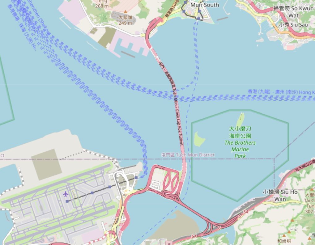
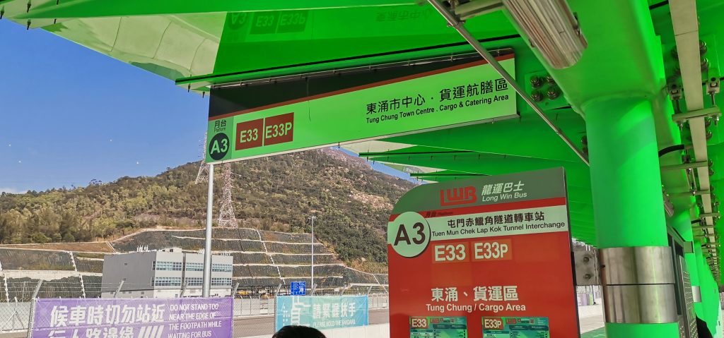
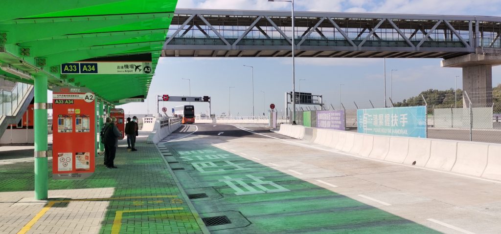
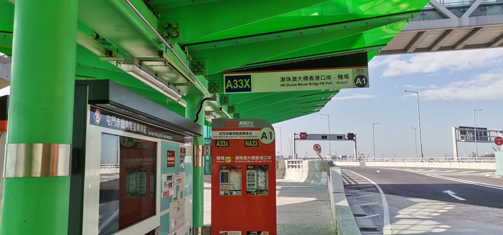
The Tuen Mun–Chek Lap Kok Link (Chinese: 屯門至赤鱲角連接路, abbreviated as TM–CLKL) is a road project in the New Territories, Hong Kong. It comprises two elements: the “Northern Connection” and the “Southern Connection”. The Northern Connection comprises of an undersea tunnel crossing the Urmston Road, linking Tuen Mun to the “Boundary Crossing Facilities” (BCF), an artificial peninsula connected to Hong Kong International Airport. The Southern Connection, officially named Shun Long Road (Chinese: 順朗路), comprises viaducts linking the BCF to North Lantau Highway on Lantau Island.
The construction of the link has helped facilitate travel between the Northwest New Territories (Tuen Mun and Yuen Long Districts) and the Hong Kong International Airport and the Hong Kong-Zhuhai-Macau Bridge (Hong Kong Port).
The tunnel portion is a two-lane dual carriageway approximately 5 kilometres long. The dual sub-sea tunnels were bored up to 55 metres below sea level using the Tuen Mun – Chek Lap Kok TBM, the world’s largest tunnel boring machine.
Originally scheduled for opening in 2018, completion of the link had been delayed for two years. It opened to traffic on 27 December 2020.
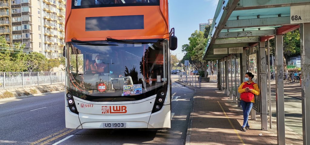
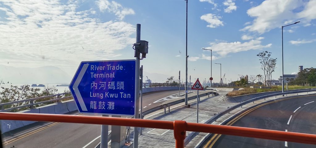
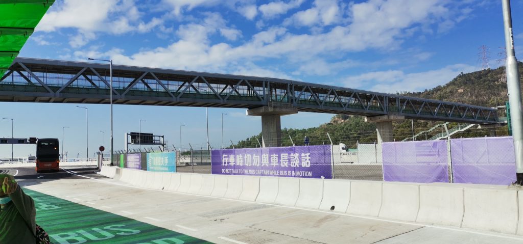
A34 at Hung Tsui Kiu on Castle Peak Road in Yuen Long. The bus is packed with seniors test-running the route.Near Butterfly Bay in Tuen MunCrossover between the bus stations at the InterchangeOn the other side of the InterchangeTo Tung Chung city centreTo the AirportTo the “Boundary Crossing Facilities” (BCF)
12-26-20 China’s first combined highway and railway cross-sea bridge, the Pingtan strait bridge, comes into use on Sat, after 7 years of construction overcoming obstacles including weather, hydrology and geology, ending the lack of railways on Pingtan island in E China’s Fujian Province.
Chinese bullet train Fuxing CR300 with speed of 250km/h has been put into use recently. Fuxing train series speeding between 160 and 350 km/h have all been in use. Fuxing bullet trains are expected to be operating in every provincial area in Chinese mainland by next year.